We have a few storms this morning and we’ll be warm this afternoon, but the forecast stays on the cool side for the foreseeable future.
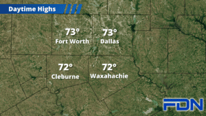
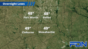
Showers this morning will include some thunderstorms as we get into the mid-late morning hours, with a few strong storms with hail and strong winds possible as well. After noon we should dry out and warm up to the low 70’s before the cooler air arrives to bring us down to the upper 40’s overnight.
Tomorrow will be windy and cool with highs in the mid 50’s and northwest winds of 10-15 MPH, gusting to 20-25 MPH. Overnight lows tomorrow night drop to the low 40’s. Wednesday, Thursday and Friday will stay cooler with varying, light winds for Thanksgiving travel and festivities. Overnight lows will remain chilly in the upper 30’s and low 40’s.
Our next storm system arrives next weekend, bringing a chance of some showers and cooler temps as we’ll stay in the 50’s Saturday and then only reach the low 50’s Sunday. Overnight lows look to drop into the 30’s. Despite the hype some are sharing, I don’t see wintry precipitation involved at this point – but I’ll keep an eye on it in case colder air looks to intrude farther south and can keep moisture around (not likely). Stay tuned!