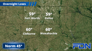
There are a few chances of showers/storms this week, starting with a low chance this afternoon and tonight.
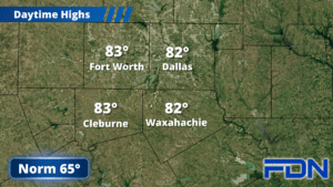
Today will be a warm day with highs in the low 80’s and breezy south winds. As far as storm chances, overall the chance is fairly low – at least, the coverage will be. We could see 2-3 storms pop up later this afternoon, and then another chance of a few comes up tonight. It’s not going to be a widespread event by any means, but the few storms we do see could become strong/severe with large hail and strong winds being the main concern. Tornado risk is low. It is possible we could see nothing – storms could stay out of our area, but I will be monitoring to see where storms pop and where they go.
Tomorrow will be another warm one with highs in the mid 80’s and lighter winds. A weak front will mosey in and change wind directions, but won’t really do anything for temperatures.
Wednesday starts dry, and will be yet another warm day with highs around 80° and winds shifting back to the south. Rain chances start to increase late in the afternoon/evening as our next system approaches from the west. Rian coverage continues to increase overnight, and Thursday will be a cloudy, rainy day with highs around 70° and breezy south winds. Friday starts with lingering rain, but that should taper off as we go through the day. A cold front brings drier air and will hold temps in the low 70’s in the afternoon, and lows will dip into the mid 40’s overnight. This sets up a cooler weekend with temperatures in the 60’s (which is closer to ‘normal’ for this time of year) and lows in the 40’s.