Today will feel like anything but December…but a strong cold front will bring us back to normal!
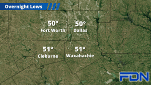
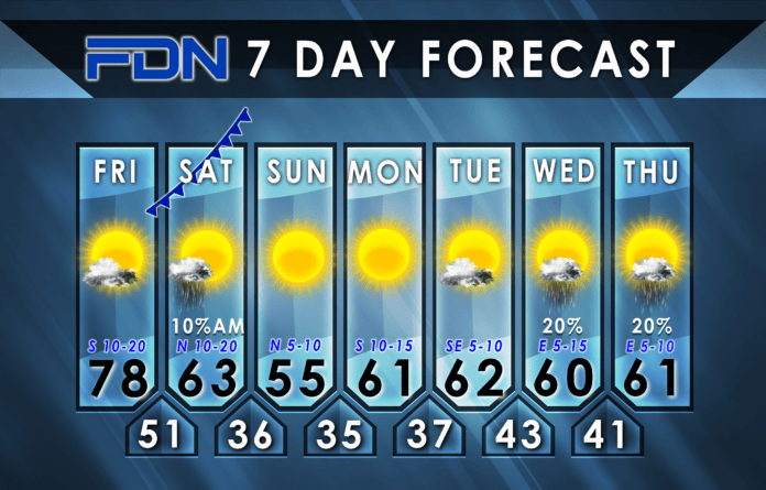
Today will be warm and windy with decreasing clouds. Temps will reach for 80° this afternoon as winds crank up to 10-20 MPH sustained, gusting up to 25-30 MPH. Lows tonight should settle in the low 50’s.
Tomorrow morning a strong cold front arrives, and could bring a few light showers as it moves through. It should clear our area by noon. We’ll hit our high temperature ahead of the front – I think we’ll make it to the low 60’s where the front moves through first, but could get into the mid 60’s where it moves in later in the morning (Corsicana area). Considering compressional heating along the front as a factor too, we could see some briefly jump to the upper 60’s before temps start dropping. The Storm Prediction Center still has a marginal risk of severe weather as far as Kaufman/Corsicana/Groesbeck, but I don’t buy it. I expect it to be a pretty uneventful frontal arrival. Behind it, though, temps drop and northerly winds start gusting. It’s going to be a chilly, blustery day tomorrow. Lows tomorrow night will dip into the mid 30’s.
Sunday the winds calm down and we’ll stay cool with sunny skies and highs in the mid 50’s, and then lows drop back to the mid 30’s tomorrow night.
Southerly winds return Monday, but temps will remain seasonal in the low 60’s. Winds will be breezy, but not overwhelming. Tuesday will be about the same, but with less wind and a few more clouds. Lows Monday night dip into the upper 30’s, and then the low 40’s Tuesday night.
Our next system arrives mid-late next week, with low rain chances Wednesday and Thursday. We’ll stay in the low 60’s for temps. Right now it looks like better rain chances arrive Friday, so stay tuned for a forecast update this evening that should have more detail on that.


