The forecast has some ups, downs, gusty winds and another storm system – all leading to a stronger cold front on the horizon (long-winded polar vortex discussion at the end).
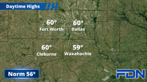
Today we’re starting cloudy but will see more sun in the afternoon as highs climb into the upper 50’s to around 60° with light east winds. Tonight a cold front moves through that will bring us into the mid 30’s, and tomorrow will be a bit cooler with highs in the low 50’s. Sunday we warm up to around 60° and winds start picking up from the southeast. Sunday night we’ll only cool into the low 40’s.
Monday our next storm system arrives and brings another round of showers and thunderstorms to our area. This one could be a bit more noisy, but the severe weather should stay to our south. Monday will be a windy day with gusty south wind shifting to the west. Rain should end Monday night, and Tuesday will be dry. Some automated forecasts on websites and apps have been advertising snow for Tuesday, but that doesn’t look to the be case. It will be a windy, cold day, though, so it’ll still have that winter flare – just without the fun stuff. Tuesday night we drop into the 20’s for a pretty decent freeze (take that, mosquitos) and then we rebound to the upper 50’s Wednesday and mid 60’s Thursday. Both days look breezy as well.
Ok, so here’s the part many of you are waiting for. There are changes in the Polar Vortex, and an intrusion of arctic air is becoming more certain as models continue to argue it will occur – and that it is likely to bring cold air to North-Central Texas. There is still disagreement among those models about timing and just how cold we will get, so there isn’t a whole lot I can say at this moment. One model shows it arriving in Texas on the 12th, another on the 15th. That’s quite the variation, so we will need more time to see what consensus they can reach. I can also say with some confidence that the coldest air is likely to stay north of us. Models seem to agree we might have a few mornings in the 20’s, and neither of the major models seem to think it will last very long. But, again, there is still a lot of time for all of this to change.
I’ve already seen one on-air meteorologist in Oklahoma calling this the coldest front since February 2021. I think that is very presumptuous, and just more unnecessary hype. Plus, it will undoubtedly get colder there than it does here. Neither model shows the single-digit temps shown on that screenshot people keep sharing. For now, stay tuned for updates – I will keep you informed as I monitor trends and see how this evolves over time.