Today is our last day of excessive heat before things start to change – and the beginning of that transition could include some overnight storms.
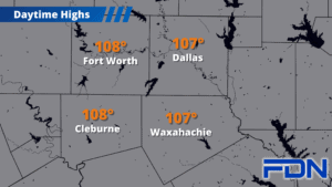
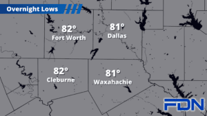
Today will be another excessively hot day with Excessive Heat Warnings in effect. Temperatures will be in the 107°-109° range across our area. It will be some of the most extreme heat we’ve seen this season (in early September – just ridiculous). Tonight we’ll start to see storms form in Oklahoma and head south into our area. Some of these storms could be strong/severe with strong winds and hail. Tornadoes are not expected. Overall I expect about a 30% chance you’ll get a storm.
A few storms may persist into early tomorrow morning, but I don’t think they’ll go on to affect events like the Ellis County Emergency Preparedness Fair. Tomorrow afternoon we’ll warm up to around 100°, but we won’t make it into Excessive Heat range (105°) – in fact some of us may not even reach the triple digits! Sunday stays a few degrees cooler in the mid-upper 90’s, then Monday we’re in the mid 90’s.
Monday night/early Tuesday morning the big cold front arrives, and I have a 40% chance of showers/storms Monday (best chance Monday night) and a 50% chance Tuesday with highs Tuesday in the mid 80’s! Wednesday a few more showers/storms will be possible, with a lower chance Thursday. High temperatures will remain in the low-mid 80’s. Beyond that is a big guess, but trends suggest we’ll stay below the triple digits – and it will be pretty difficult for us to get back into any kind of excessive heat as we get into the second half of September.