


Tropical Weather May Target Gulf of Mexico Next Week
AccuWeather Global Weather Center – June 3, 2021 – A relentless pattern of persistent showers and thunderstorms is not showing signs of easing across parts of waterlogged Texas and Louisiana. And to make matters more concerning, AccuWeather meteorologists say that a storm and tropical moisture from the Gulf of Mexico may team up to aggravate existing flooding and potentially lead to new flooding problems.
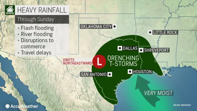
The initial flooding concern will be the result of a storm in the middle levels of the atmosphere that is forecast to form over Texas later this week and crawl eastward through next week, according to AccuWeather Senior Meteorologist Brett Anderson.
“That mid-level storm will trigger drenching showers and locally severe thunderstorms and incidents of flash flooding over a several-day period mainly from Thursday to Sunday,” Anderson said.
Slow Moving Storm Will Impact Saturated Areas
The slow-moving storm and its circulation will pump Gulf of Mexico moisture northward over much of Texas and Louisiana as well as neighboring portions of Oklahoma, Arkansas and Mississippi.
The new batch of flooding rain is coming to an area that had more than its fair share in May.
Both Victoria, Texas, and Lake Charles, Louisiana, received more than 20 inches of rain during May, which was nearly four times the normal rainfall for the month for each city, and much of that rain fell in a mere 10 days.
The tremendous rainfall was not just isolated to these two cities. Rainfall totals in the double digits were reported from parts of the lower Rio Grande Valley to central Texas and much of southern Louisiana. Houston, Port Arthur and Austin, Texas, as well as New Orleans and Lafayette, Louisiana, all received double-digit rainfall during May.
The May rainfall has left the ground saturated in many locations from central Texas to southern Louisiana. Area streams, rivers and bayous are swollen to the point where flooding from prior rainfall has continued into the start of June.
River, Lakes, Creeks Are Approaching Flood Stages
The Trinity River at Liberty, Texas, a city located northeast of Houston, teetered at major flood stage of 29 feet during much of the Memorial Day weekend, according to National Weather Service hydrological data. The Trinity was only receding at a snail’s pace as of Wednesday. Long-range water level projections on the Trinity and other rivers in the region were not incorporating the potential amount of rain that may fall in the next week to 10 days.
Even smaller creeks in central and western Texas periodically swelled rapidly to moderate and major flood stage over the holiday weekend with more rounds of storms on the way.
However, it is not just this week’s mid-level storm that will be a problem. Showers and thunderstorms from a moist flow of air from the Gulf will occur before and after the storm’s direct impact.
“Regardless of what weather systems happen to be in the neighborhood, this is a pattern that is ripe for multiple rounds of showers and thunderstorms that focus on areas of central and east Texas and Louisiana that have been inundated in recent weeks with frequent heavy rain events and flooding,” AccuWeather Senior Meteorologist Joe Lundberg said.
Source: AccuWeather


