Temperatures are on the upswing for the rest of this week, but a cold front Sunday night will bring us back to cooler temps in time to ring in 2024.
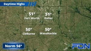
Today we should have a few clouds hanging around as we remain under the backside of a large low pressure system. That dry air will prevent any precipitation from up north from reaching us (sorry, we won’t get any of that Oklahoma snow – and I doubt much, if any of that, is reaching the ground up there anyway). Dew points in the 20’s and 30’s just won’t allow it. It will allow us to cool down into the upper 20’s tonight, so it’s time to drip the faucets and cover the outdoor spigots.
Tomorrow we warm up a bit into the mid 50’s with breezy west winds, but we’ll still cool down overnight to around 30°. This weekend we’ll warm up to the low 60’s, and overnight lows will be in the upper 30’s Saturday night. Sunday night our next cold front moves in, bringing us back to the low 30’s overnight lows and the upper 40’s/low 50’s for highs for the first few days of the new year.
Our next chance of rain arrives Tuesday, and I’m watching trends to see how this might unfold. One model says it will move right over us, the other says it will stay mostly south of us. I think we have a chance of rain either way, but I’m holding it at 30% for now. We’ll see if confidence increases as we get closer. Stay tuned!