Impact of Storm Will Affect Those Out of Path Due To Transport Issues
AccuWeather Global Weather Center – January 31, 2022 – At least 90 million people across 14 states were under a winter storm watch or warning by Monday evening as the makings of a far-reaching, disruptive winter storm that will track over a 2,000-mile stretch of the United States.

AccuWeather Chief Meteorologist Jonathan Porter warned that not only will the storm impact the 90 million people in its path, but also retailers and consumers as weather conditions may slow down or even stop a few trucks from transporting goods through parts of the Central U.S. for a few days this week.

“We could be looking at a big mess in moving products to where people and businesses need them as a result of our latest winter storm, and this interruption in the supply chain may be felt for weeks,” Porter said.

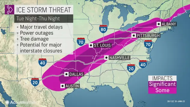
Denver, Dallas and Detroit are among the major metro areas expected to face wintry consequences and potential travel trouble, forecasters say. Major highway arteries across the Great Lakes and Ohio Valley southwestward into Missouri, Kansas, Arkansas and Texas may also be impacted, including parts of I-80, I-90, I-70, I-40 and even parts of I-20, according to AccuWeather Lead Storm Warning Meteorologist Billy Clark.
Winter and spring will be duking it out across the middle of the nation right around the time Punxsutawney Phil makes his highly anticipated forecast on Feb. 2, Groundhog Day. The clash of seasons will commence as a fresh wave of Arctic air dives southward into the northern Plains and warm, moist air from the Gulf of Mexico surges northward.
An expansive area of snow and ice, extending along an approximate 2,000-mile-long swath of the country, is expected to break out as early as Tuesday night from portions of Colorado and New Mexico to Kansas, Oklahoma, Missouri, Illinois, Indiana, and Michigan. By Wednesday night, the wintry hazards are forecast to expand farther south and east into Texas, Arkansas, and part of the lower Ohio Valley.
“Depending on the exact track of the storm, an extended zone of icing will develop from central Texas extending through the Ohio Valley. Areas like Dallas, Little Rock, and Indianapolis could be under a significant ice threat around the middle of this week,” AccuWeather Meteorologist Joe Bauer said.

“Any areas that receive significant icing from this storm can experience downed trees and power lines,” Bauer said.
“A broad area of ice accretion of 0.25 to 0.50 of an inch is anticipated with this storm in the Central states and is serious enough, but there is the potential for 0.50 of an inch to 1 inch of accretion in some areas, which could be devastating to some communities,” AccuWeather Senior Meteorologist Alex Sosnowski said.
For some areas in this corridor, the period of icing could last 12-24 hours or more.
Travel will become extremely difficult and dangerous especially where freezing rain is the primary type of icy precipitation. Freezing rain creates a glaze of ice on untreated roads and sidewalks, and can cling to trees and power lines and lead to power outages. Widespread power outages are likely from Dallas to Columbus.

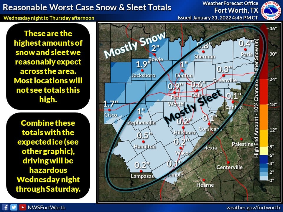
Just to the north and west of the icy corridor will be a zone of accumulating, plowable snowfall.
The heaviest snow is likely to fall across the central and southern Rockies where the AccuWeather Local StormMax™ of 36 inches is most likely to occur. But forecasters caution that even outside of the mountains, enough snow to cause slippery roadways and disruptions to daily routines will encompass a broad area.
“A swath of heavy snow accumulating in excess of 1-inch per hour could extend from portions of eastern Kansas through central Illinois, northern Indiana, southeast Michigan, and northwest Ohio, where totals of over 6 inches can occur,” Bauer said.
Enough snow to shovel and plow is forecast throughout the Chicago area, but a tremendous variance in snowfall totals is expected from northwest to southeast across the metro area with the heaviest amount of snow likely to fall toward central Illinois and in northwestern Indiana.

Even portions of western Texas, such as Amarillo and Midland, and Oklahoma, including Oklahoma City, may not be spared from the storm’s wintry side as ongoing mild weather is replaced by a harsh chill.
Temperatures can plummet 20 to 30 degrees over 24 hours across the South Central states, according to Bauer.
The preceding warmth in this part of the country will allow for any snow to initially melt on contact with roads and sidewalks. However, as the snow continues to fall and temperatures plummet, conditions can turn icy in a hurry.

The rush of cold air southward may be potent enough for some snow and ice to reach as far south as the Big Bend of Texas late Wednesday into Thursday.
During the middle of February 2021, Arctic air plunged deep into Texas along with multiple rounds of snow and ice that persisted for one to two weeks. The harsh wintry weather triggered lasting power outages, while roads in some areas resembled the Arctic tundra,” Sosnowski said, adding that temperatures are likely to bottom out 10-20 degrees higher compared to last February’s outbreak.
“While the amount snow and ice in some areas could rival that of a year ago, the areal coverage in the region should be significantly less and the pattern itself should not last more than a couple of days,” he said. “For example, temperatures are forecast to bottom out in the 20s around San Antonio and Austin later this week, compared to the lower teens and single digits last February. Where power outages occur, they could be long-lasting and some roads will be icy and dangerous for a time in the Lone Star State,” Sosnowski said.
The broad nature of the storm is expected to lead to significant delays for travelers both on the road and in the air. Airline passengers with arrival and departure flights or connections in Denver, Dallas, St. Louis, Chicago, Detroit, and Indianapolis should be prepared to face weather-related delays around the middle of the week.

In 2011, a storm on Groundhog Day brought immense snow and travel problems to Chicago. The Windy City may be right on the edge of significant snow accumulations with this storm, according to forecasters.
As the storm shifts toward the Eastern Seaboard late in the week, weather-related travel woes can directly affect some of the larger Northeast hubs. Unlike the latest bomb cyclone that dumped feet of snow, the upcoming storm is expected to bring a mixed bag of precipitation to the region.
AccuWeather meteorologists stress that even small changes in the track of the storm can have large implications on precipitation types and whether a location lies within the corridor of rain, steady snow, significant icing, or nuisance flurries and light snow. In addition, a push of dry air behind the storm could plunge farther south than currently anticipated, leading to lower snowfall amounts on the northern and western edges of precipitation.
“Both the press of Arctic cold and the sweep of dry air will be critical for all rain versus a change to ice and snow from the mid-Atlantic to southeastern New England spanning Thursday to Friday,” Sosnowski said.

Forecasters say impacts from the storm will not just be of the wintry variety and that there could be a concern for severe weather as well. To the south and east of the corridor of icy mix, soaking rain and thunderstorms are likely.
“Heavy rain from eastern Texas through the Tennessee Valley and portions of the Southeast can lead to flash flooding and localized severe weather,” Bauer said.
AccuWeather meteorologists will continue to monitor the latest trends with the storm and provide more details on exact timing, snowfall amounts and areas at risk for a dangerous ice storm in the coming days.


