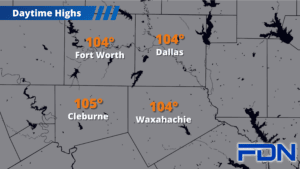
Excessive Heat Warnings continue for one more day before we finally bring a cold front in that will bring at least a few days of relief from the triple digits.
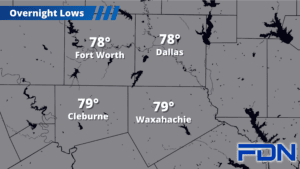
Today the Excessive Heat Warning continues until 8:00 pm as afternoon highs warm up to the 104°-105° range – a hair less hot than yesterday. Tomorrow we’ll warm up to around 102°-103° before a cold front arrives late tomorrow afternoon/evening, bringing a low chance of a few isolated showers/storms and a wind shift to the north. Severe weather is not expected. If the front arrives a little earlier, afternoon highs could be cooler.
Saturday and Sunday we’ll be in the mid-upper 90’s. I have us at 97° Saturday and 98° Sunday, but we will have north winds both days which should help keep the humidity down. I’m hopeful we are impressed by the front and those temps trend downward a few degrees, but we’ll take what we can get.
Triple digits return Monday and continue for at least a while, though it doesn’t look like we’ll be quite as hot as we have been this week. I’ll continue watching that trend, and watching for our next break!