The first of a series of storm systems moves in today, and we’ll see overnight lows running a bit warmer as well.
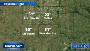
We’re starting out cloudy but dry this morning, some frost here and there as well. Clouds will continue to thicken as the day progresses, and the rain approaches from the west after noon – especially after 2-3 pm. It will be mostly showers, though we could get a rumble of thunder or two this evening. Highs this afternoon will reach the low 50’s for most of us, and we could get closer to the mid 50’s along and east of I-45.
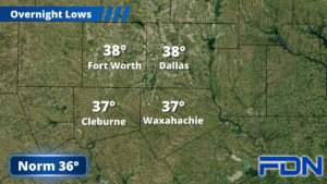
Dry air will push the rain out overnight and we’ll stay in the upper 30’s for lows. Tomorrow we start with patchy fog and will warm up to the mid 50’s. Tomorrow night we dip down to the mid 30’s, with some low 30’s possible in low lying/rural areas. Thursday will be pretty similar with patchy fog to start and afternoon highs in the mid 50’s. Lows will be around 40°.
Friday our next system moves in and brings widespread rain. Highs will only reach the low 50’s, and then rain continues Friday night with lows in the upper 30’s. Saturday we return the mid 50’s with a few morning showers possible before we dry out in the afternoon.
Sunday we should crack 60°, and then Monday we reach the low 60’s as a third storm system moves through and brings more widespread rain. This pattern that’s being called a “storm train” is typical of El Nino as the jet stream is parked close to or on top of us, serving as the “tracks”. Long-term models suggest we could look at yet another system moving in late next week or early the following week – but we’ll have to wait and see if those models hold. What isn’t in the forecast is any intrusions of arctic air or polar plunges.