Temperatures are on a warming trend today, but another late-week cold front will bring us back down to the 70’s.
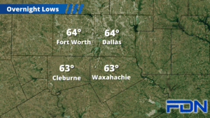
Today we’ll get into the mid-upper 80’s, some maybe getting close to 90° before we drop into the low 60’s overnight. Tomorrow and Wednesday we should stay closer to the mid 80’s as southwest winds pick up. A disturbance and a low pressure center brewing in the gulf could come together Tuesday afternoon/evening and produce a few showers/storms in our area, but it won’t be very high coverage.
Thursday get closer to the 90° mark with breezy southwest winds as a cold front approaches. While we could see a few showers/storms from the front, it looks like the almighty cap will keep things fairly calm as the front moves through – that said, I have a 10% chance, and I’ll monitor it. Friday, Saturday and Sunday we’ll be in the 70’s with breezy north winds.