Temperatures go well above normal as our next round of rain approaches – but a cold front will give us December temperatures just in time for Christmas Day.
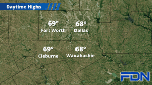
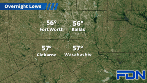
Today we’ll get a break from the rain, with high temperatures in the upper 60’s – around 10° above normal. Lows tonight will dip down into the upper 50’s.
Tomorrow we will start the day dry, but will once again see rain increasing in coverage. We will have a mix of scattered showers and thunderstorms in our area by the afternoon/evening hours, which will continue overnight. Early tomorrow morning a line of storms should approach from the west, packing heavy rain and gusty winds and likely arriving between 4-6 am. It doesn’t look right now like these storms will be severe – but they could get a little rowdy. I’ll continue monitoring this potential today and bring updates as necessary. Be prepared for another inch or two of rain before we clear out by noon or so on Christmas Eve.
Form there on, the forecast clears out and cools down. A cold front arrives Sunday night, which will bring overnight lows down to around 40°. Highs Christmas Day will only be in the low-mid 50’s, and winds will be gusty out of the northwest. Lows that night will drop down into the low 30’s – bringing a light freeze to some. Tuesday will be another blustery day with gusty winds and highs in the mid 50’s, then Wednesday and Thursday look breezy and a bit warmer with highs in the upper 50’s.