We’re heading into a wet weekend that will be followed by a cooler start to next week.
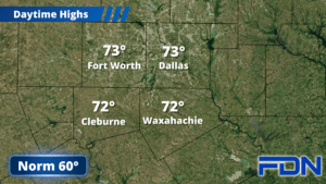
Today we will be mostly dry, but could see a few showers/thunderstorms develop – especially east of I-35. There could be a heavy downpour or two in those storms that do develop. Highs later today will be in the low 70’s.
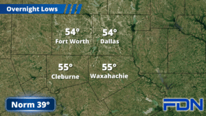
Tomorrow our first round of widespread rain arrives, and this will be a pretty good soaking across our area. Rain should be mostly confined to the morning hours, tapering off in the afternoon. Highs should only reach the low 60’s tomorrow afternoon, and overnight lows will be in the low 50’s.
Sunday morning another round of showers and thunderstorms moves through, and it looks like there could be a couple of stronger storms mixed in. The Storm Prediction Center has a marginal risk of severe weather starting east of I-35 and continuing eastward. If storms do reach severe limits in our area, it will probably be as they are moving through – leading them to intensify as they move east. I don’t expect more than some gusty winds and small hail in the stronger storms, and those will be isolated. Sunday afternoon we should dry out, then Sunday evening I think we MIGHT get a sprinkle or two…but most of the moisture on the back side of the system will be north of us. Sunday night we’ll drop into the mid 30’s.
Monday we will have a cool, breezy day with highs in the 50’s and winds out of the northwest. Lows again dip into the mid 30’s, and then Tuesday we’ll be closer to the 60° mark. Wednesday and Thursday we’ll be in the mid 60’s with lows Wednesday night around 40°. It’ll be chilly in time for Valentine’s dinner dates, so bring a jacket or sweater!