The first cold front in our double whammy has moved through, and a much deeper front is on the way that will bring seriously cold temps and even some wintry precipitation.
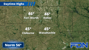
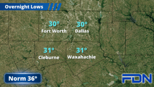
Today will be chilly with highs only reaching the mid 40’s and northwest winds of 20-25 MPH gusting to 30-35 MPH. A Wind Advisory continues through noon today. Tonight we dip into the low 30’s, and most – if not all – of us will drop below freezing. Tomorrow is looking more pleasant as we’ll get closer to 60°, though breezy winds will continue – this time out of the south. This will be your last day above freezing for a while!
Tomorrow night the deeper front arrives, and we’ll go from nearly 60° tomorrow to the upper teens by Sunday morning. Winds will shift to the northwest and be quite breezy, bringing wind chills down into the single digits. Sunday we will likely stay below freezing, only reaching the low 30’s. Sunday night we’ll see precipitation move in as temperatures drop into the mid teens, bringing a mix of sleet and snow to our area. This could make travel treacherous Monday as highs only reach the mid 20’s with more breezy north winds. Monday night we’ll drop into the low teens, and stay cold Tuesday with temps remaining in the 20’s. Tuesday night we dip once again into the low-mid teens.
Wednesday we thaw out with highs in the mid 40’s, though we will drop back into the upper 20’s Wednesday night. Thursday looks even warmer with highs in the mid 40’s.