


Rain, Rain and Rain Headed Is For Texas Cities
AccuWeather Global Weather Center – May 23, 2022 – A surge of warmth has been felt across the region in recent days. For some, the hot streak has been even longer. Cities like Dallas and Austin, Texas, have spent more than a week with temperatures in the 90s F. For residents looking for some relief from the heat, a change in the weather pattern could bring in a welcome change.
This heat has been compounded by persistent dry weather across the south-central United States, worsening the drought in the area.
Across Texas, cities from Dallas to Houston and San Antonio, have had less than 2 inches of rain in the so far in May, well below normal. It’s been even drier for some; cities like Austin and Lubbock have had less than half an inch of rain so far this month, bringing the drought to extreme and exceptional levels, according to the U.S. Drought Monitor.
For the new week, the jet stream is expected to dive southward across the center of the country. This will usher in some cooler conditions across the region. After high temperatures reach the upper 80s to the middle 90s early in the weekend, thermometer readings are likely to drop below normal and into the 70s for the first half of the new week.
The pattern change will also open the door for the return of wet weather.
“Multiple storms are expected to dive into the southern Plains early week, inducing showers and thunderstorms from Texas to Missouri from Monday through Wednesday,” said AccuWeather Meteorologist Alex DaSilva.
The clash of hot, steamy air ahead of the storm, and cooler conditions following behind, will help to prime the atmosphere for severe thunderstorms on Monday.
Locations at risk for the severe storms include eastern New Mexico, the western half of Oklahoma and western and central Texas to the Mexico border. Threats such as intense downpours and hail are possible with thunderstorms that erupt in this area late on Monday.
Areas that are hit by downpours several days in a row are likely to see the highest rainfall amounts.
“While the location of the heaviest rain will be determined by the exact track of each storm, rainfall amounts of as much as 4-8 inches are possible in those areas,” explained DaSilva.
Early indications suggest that communities from Dallas and Houston, to Shreveport, Louisiana, and Little Rock, Arkansas, could all experience the heaviest rainfall.
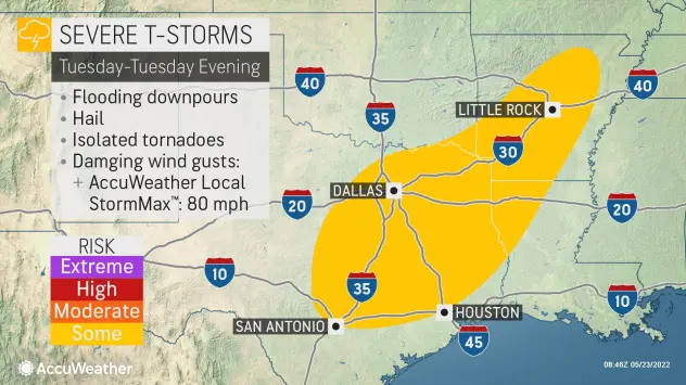
A slow-moving area of low pressure will continue crawling across the state of Texas Tuesday through Tuesday evening where severe storms are expected to erupt. The major threat for any storm from San Antonio into Dallas will be intense downpours, but hail, damaging wind gusts and even an isolated tornado are possible in the strongest storms.
About AccuWeather, Inc. and AccuWeather.com
AccuWeather, recognized and documented as the most accurate source of weather forecasts and warnings in the world, has saved tens of thousands of lives, prevented hundreds of thousands of injuries and tens of billions of dollars in property damage. With global headquarters in State College, PA and other offices around the world, AccuWeather serves more than 1.5 billion people daily to help them plan their lives and get more out of their day through digital media properties, such as AccuWeather.com and mobile, as well as radio, television, newspapers, and the national 24/7 AccuWeather Network channel. Additionally, AccuWeather produces and distributes news, weather content, and video for more than 180,000 third-party websites.


