Below-normal temps stick around for a couple of days, but we’ll warm up and bring in a chance of showers and storms to end November.
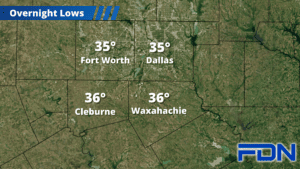
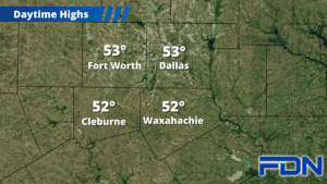
We woke up to some of the coldest temps we’ve had this season, with temps dipping into the upper 20’s and low 30’s area-wide. This morning’s sunny skies will be replaced by increasing clouds as the day goes on, keeping highs in the low 50’s. Tonight’s forecast low will be warmer than expected thanks to those clouds holding in some of our daytime heating, so we should only drop into the mid 30’s. Tomorrow we’ll see more sun and warmer temps, reaching the upper 50’s to around 60°.
Wednesday will be warmer with highs in the low 60’s and modest southwest winds, and overnight lows will only drop into the upper 40’s. We’ll start to see light rain increase in coverage Wednesday night, then we’ll see more widespread showers and a few thunderstorms Thursday (highest coverage east of I-35). I don’t expect severe weather with this event, at least not here. Thursday night’s lows will settle around the mid 40’s.
Rain will clear out by Friday, and breezy northwest winds will keep us cool with highs in the upper 50’s. Friday night we drop into the low 40’s, and then we warm up to the low 60’s for the weekend with a low chance of rain on Saturday.
.